April 18, 2011
Now I’m in a 5th continent, Asia. I am in Rumjatar, Nepal. Its coordinates are 27° 18’ 0” N and 86° 33’ 0” E. I am here because Rumjatar is very close to Mount Everest, the tallest mountain in the world. I am going to go visit Mount Everest tomorrow. I’m not planning to hike very far, but hopefully I can get a wonderful view of the surrounding area.
 |
| Mount Everest: http://en.wikipedia.org/wiki/Himalayas |
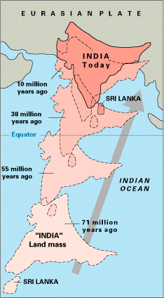
Mount Everest is part of the Himalaya mountain range that crosses through Nepal, India, Bhutan and a few other countries. The Himalayas were formed by a convergent collision boundary between the Indo-Australian and the Eurasian plates. The Indo-Australian plate used to be on the coast of Africa. It then began to move at about 15 cm per year until it crashed into the Eurasian plate. The collision made the plates buckle and go upwards, forming mountains.
 |
| India's Movement: There are no volcanoes here, because the lava from the earth’s core is not bubbling upwards like in a subduction boundary or a divergent boundary. However, there have been a number of earthquakes in Nepal. The most recent large-ish quake was on December 8, 2008. It was a 6.0 earthquake. The most recent earthquake was a 4.2 on February 22, 2011. A larger earthquake happened on August 26, 1833. It was a 7.5 earthquake. Now I need to go pack for my Mount Everest trip tomorrow. I am hoping for good weather! J |
No comments:
Post a Comment